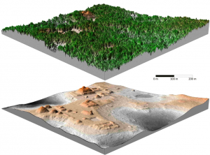
With support from the National Science Foundation (NSF), the University of Houston’s National Center for Airborne Laser Mapping (NCALM) has, in the past few years: located ancient ruins, identified levees in danger of failing, charted land erosion following hurricanes, created flood maps for urban areas, found near-drought conditions in seemingly healthy plants, mapped the sea floor, charted areas prone to landslides, and helped identify how the presence of life impacts geographical features.
And that’s just scratching the surface.
Given all that it has done and can do in the future, the NSF has chosen to renew funding for the center, granting it approximately $3.18 million to continue its work for the next five years.
“This is a big vote of confidence,” said Ramesh Shrestha, NCALM director and Hugh Roy and Lilly Cranz Cullen Distinguished Professor of civil and environmental engineering at UH’s Cullen College of Engineering. “This funding is a signal that the technology and imaging techniques we develop have great value to researchers across the sciences.”
NCALM’s roots trace back to 1996 at the University of Florida. It was there that Shrestha and NCALM Chief Scientist Bill Carter first began working with the center’s core technology, Light Detection and Ranging, or LiDAR. With LiDAR, researchers fly a plane over an area they want to map, shooting hundreds of thousand of laser bursts per second at the ground. How that light returns to its source can be used to create extremely detailed topographical maps, even through dense vegetation and murky water.
Over the years, such maps have proven valuable to researchers in a number of disciplines. NCALM, in response, has dedicated itself to being a resource for outside investigators as well as a home to basic and applied research. Roughly 40 NSF-funded principle investigators have conducted research with data delivered by the center. Under a special seed program, it has provided data and maps that have been used in approximately 80 M.S. and Ph.D. students in their theses and dissertations; and hundreds of peer reviewed articles that utilized NCALM observations have been published, including featured articles in Nature, Physics Today and Science.
In 2010, Shrestha and Carter moved the center from Florida to the University of Houston, where they were given the opportunity to grow NCALM from three researchers to seven – six of whom are now on board, including new Co-PI and assistant professor of civil and environmental engineering Craig Glennie.
This growth has also allowed the center to expand into new technologies, including satellite data analysis, multi-sensor image processing that combines GPS with ground-based and airborne LiDAR; and hyperspectral imaging.
In addition, the move to UH set the stage for the creation of a new multidisciplinary master’s degree program in geosensing systems engineering and science. Just three years old, already more than 20 students are enrolled in the program.
Looking ahead, the center will continue improving LiDAR and other NCALM-related technologies, said Shrestha. Current efforts include a project led by Glennie to develop smaller and cheaper LiDAR systems; systems that can scan the floor of lakes and the ocean through deeper and deeper water; and systems that use two or more different colored lasers, which may reveal properties of the materials they hit. All of these efforts will benefit from the continued support of the NSF.
“If you talk to any PI that has used our data over the past 10 years, they’ll tell you we deliver the highest quality data. They are our biggest supporters. Thanks to the continued support of the NSF, we will be able to keep providing them with the best possible research-quality data for at least the next five years,” Shrestha said.
Acknowledgement: NCALM is funded by Instrument and Facilities, Division of Earth Sciences, the National Science Foundation, EAR 1043051.
