One of the biggest challenges following a natural disaster is simply getting help to where it’s needed. After an event like a hurricane or earthquake, debris and standing water can block roadways, making it nearly impossible for rescue crews to know which paths will lead them to people in need.
First responders, then, often rely on aerial reconnaissance to learn which roads are passable and which need to be cleared. There are a lot of drawbacks to these flights, though. “When they bring mapping data collected in the air back, they have to land and they have to process that data. It takes a couple of hours to get it into the hands of the first responders,” said Craig Glennie, assistant professor of civil and environmental engineering with the University of Houston Cullen College of Engineering.
The National Science Foundation, then, has recently awarded Glennie a two-year, $300,000 grant to eliminate this lag time and put information into the hands of first responders in a matter of seconds. His technology: LiDAR, or Light Detection and Ranging.
Through LiDAR, hundreds of thousands of laser bursts per second are shot at the ground from an airplane. By analyzing how quickly that light returns to its source, researchers can create detailed topographical maps.
The basics of LiDAR technology itself are well developed. Glennie, in fact, serves as co-principal investigator of the UH-based National Center for Airborne Laser Mapping (NCALM), which is funded by the National Science Foundation and widely-regarded as one of the most prominent LiDAR research groups in the world.
In most situations, however, LiDAR maps don’t have to be created instantly. The real work of this project, Glennie said, will be developing algorithms that can create and interpret maps in a matter of seconds. “We want to simplify the [map creation and analysis process] a little bit so that we can make, not intricate decisions, but general conclusions about where there might be problems as soon as we collect the data.”
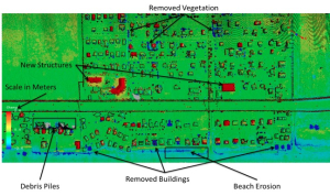
Key aspects of this work will be building algorithms that can identify how a landscape has changed after a disaster and single out the changes that matter.
“Telling first responders something has changed is important, but it doesn’t matter if a tree fell down in a middle of a field. What matters is if you have a tree that fell down on a major roadway,” Glennie said.
To develop this system, Glennie and his research team will feed their algorithms data taken from flights over Galveston Island before and after Hurricane Ike in 2008. They will then use the data to simulate a real-time change detection in response to a hurricane.
While the current grant focuses on the development of these algorithms, future efforts will likely include incorporating this system with unmanned aerial vehicles that wirelessly transmit data back to a command center, Glennie said. Such flights would be less expensive and safer than manned flights. They would also be able to stay airborne longer, allowing for larger area to be mapped and for areas of particular concern to be monitored regularly over long periods of time.
Glennie’s collaborators on this project include Ioannis Kakadiaris, Hugh Roy and Lillie Cranz Cullen University Professor of Computer Science at UH; Shishir Shah, associate professor of computer science at UH; and Cumaraswamy Vipulanandan, professor of civil and environmental engineering in UH’s Cullen College of Engineering.
