University of Houston researchers make significant strides in automating Antarctic glacier monitoring using advanced satellite radar techniques.
University of Houston researchers have validated a method that uses deep learning to automate the mapping of glacier grounding lines in Antarctica. This innovative approach could greatly enhance the accuracy and efficiency of tracking glacier retreat, a critical indicator of sea-level rise.
The study, led by Ph.D. student Natalya Ross from the Department of Civil and Environmental Engineering and co-authored by Pietro Milillo, assistant professor of Civil and Environmental Engineering, was recently published in the high-impact journal Remote Sensing of Environment.
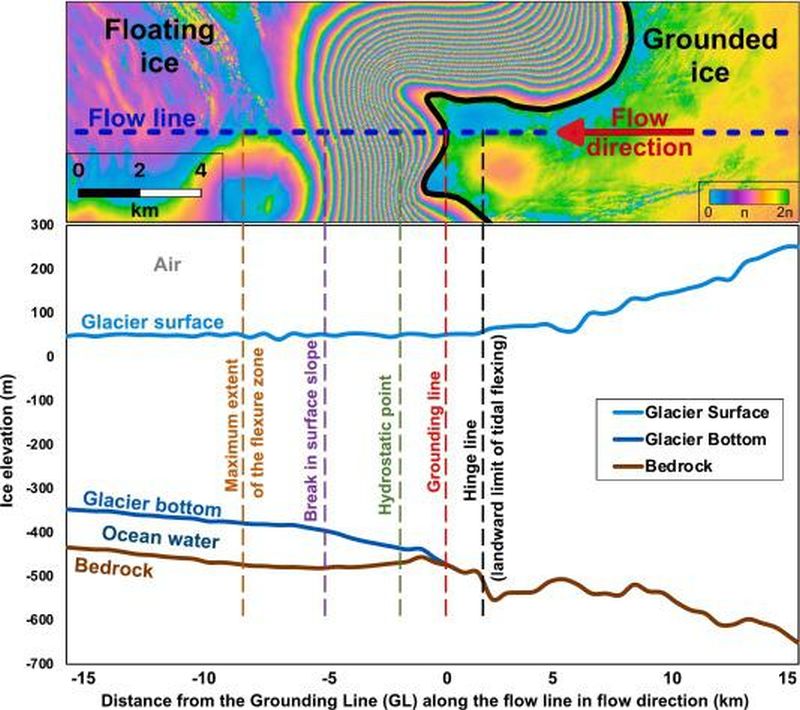
Grounding lines mark the transition point between the grounded and floating sections of glaciers, and their precise identification is crucial for understanding glacier behavior and the potential impacts of ice loss on global sea levels.
Traditionally, this mapping has relied on labor-intensive manual analysis of satellite data. However, as the volume of available data continues to increase, there is an urgent need for automated methods.
“We developed a deep learning model that outperforms existing techniques by automating the detection of grounding lines using X-band radar data,” Ross said. “This method will allow us to analyze vast datasets more quickly and accurately, helping us understand how Antarctic glaciers are evolving.”
The research team tested their method on five key glaciers in Antarctica, including the Moscow University Glacier, which has shown significant retreat in recent decades. The findings revealed that the glacier’s grounding line has been retreating at a rate of 340 meters per year since 1996, while other glaciers in the study showed no signs of retreat.
“This research underscores the importance of monitoring grounding lines, especially as we anticipate accelerated ice loss due to climate change,” Milillo said. “The ability to automate this process means we can keep pace with the growing volume of satellite data, ensuring timely analysis and response.”
The study, developed in collaboration with Luigi Dini at the Italian Space Agency through an international agreement, provided critical insights into the complex behavior of grounding zones, which fluctuate with tides. The findings also emphasized the need for continued technological advancements in satellite data analysis.
This research is supported by the NASA Cryosphere Program and the Italian Space Agency's COSMO-SkyMed mission, which supplied the high-resolution radar data used in the study. For more information about this research and its implications for glacier monitoring, visit the University of HoustonGeosensing Lab.

