Two University of Houston professors are among a group of four that have been awarded nearly $200,000 from the National Science Foundation to develop a map for coronavirus response via crowdsourcing.
The project combines the expertise of four professionals: Dr. Miao Pan, an Associate Professor of Electrical and Computer Engineering at the University of Houston; fellow UH Associate Professor, Dr. Lan Ni of the Communications department; and from the University of Texas at San Antonio, Assistant Professor Dr. Yanming Gong of Electrical and Computer Engineering, and Assistant Professor Dr. Yuanxiong Guo of the Department of Information Systems and Cyber Security.
Pan serves as the primary investigator for the grant, with the University of Houston as the leading institution. The total grant is for about $200,000, with UH and UTSA splitting the funding, from May 2020 through April 2021.
Pan said the idea for the grant came about during a research discussion call with Gong and Guo.
“During the call, we talked about the dilemma between the quick spreading of COVID-19 and the lack of healthcare resources, especially testing resources, in the United States,” he said. “We thought our knowledge in wireless networking, mobile crowdsourcing and location privacy preservation may help to proactively and dynamically allocate the limited healthcare resources to the next potential 'outburst' area or community.”
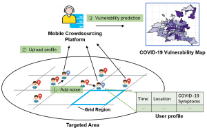
In a summary, the authors for the grant proposal argued that the development of a mapping tool to identify potential COVID-19 hot spots is needed. Current methods for testing might be inefficient, since testing centers are often at fixed locations with people requesting tests with little to no symptoms or risk factors, and better mapping could allow for better allocation of resources.
“To facilitate the dynamic deployment of COVID-19 healthcare resources, in this project, we propose to develop a fine-grained and location privacy preserving coronavirus symptom (CS) map via mobile crowdsourcing, where the symptoms may include fever, cough, and shortness of breath,” they wrote. “The proposed CS map is promising to identify the potential outbreak areas, so that the healthcare resources can proactively and efficiently be allocated (e.g., COVID-19 testing vehicles to the designated community).”
In their proposal, the authors noted that the mapping effort will have location privacy, to protect participants from bias and discrimination. Pan said that this key component was why he thought of Ni, another person he has collaborated with in the past.
“How can you build up such a map without compromising the privacy while collecting the data?” he said. “That is a question not only involving techniques, but also related to social science. That is the reason why we reached out to Dr. Lan Ni.”
A four-step development process for the mapping was described in the grant proposal:
- Creating an indexing system that accounts for participants' privacy.
- Recruiting the needed participants that will satisfy the indexing requirements.
- Using the information gathered to create a quality-assured crowdsourcing map.
- Providing strategic communication to motivate and empower community members to share information.
Pan said the project has approval for one year, with an option to extend it another year. Since being funded, they have done some theoretical analysis and modeling for the location privacy preserving COVID-19 vulnerability map construction. Pan added that he had completed one paper draft together with his doctoral students.
“In the near future, we would like to involve a few more undergraduate students, implement the proposed idea using Python or Java, and develop a location privacy preserving COVID-19 vulnerability app,” he said. “Hopefully, everything can be done within one year, so that it can be used in the coming fall or winter, when another wave of flu and coronavirus may come.”

