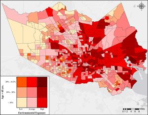
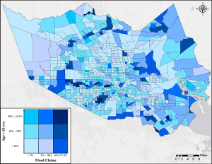
As the City of Houston and the state of Texas take steps to reopen after the COVID-19 pandemic, a trio of researchers connected to the University of Houston has developed a planning tool to identify vulnerable portions of the population most in need of testing and support, with those along industrial areas and well-traveled waterways at the most risk.
Dr. Hanadi Rifai, a professor of civil and environmental engineering at the University of Houston, is the corresponding author for a new paper, “Assessing COVID-19 Risk, Vulnerability and Infection Prevalence in Communities.” The co-authors are Dr. Winston Liaw, a professor of health systems and population health sciences at the College of Medicine; and Dr. Amin Kiaghadi, a joint affiliated postdoctoral fellow working with Rifai and Dr. Clint Dawson at the University of Texas' Oden Institute for Computational Engineering & Sciences.
Liaw said, “Using this tool, policymakers can identify neighborhoods with a higher potential for becoming the next hot spots, efficiently match community resources with community needs, and ensure that equipment, personnel, medications, and support are available to everyone, particularly the most vulnerable and those in greatest need. This strategy is essential to address historical trends that have preferentially delivered resources to those with means resulting in gaps in quality.”
“The work we did is important, but more than that it is needed by many decision-makers,” Kiaghadi said. “I am not sure there is any study like this one that could provide a holistic perspective on vulnerability by looking at various aspects of it.
Rifai said that based on preliminary analyses, there are some population groups – older people, those with preexisting health conditions, people with respiratory illnesses – that are more at-risk for transmission of and death from coronavirus. By using census data, Rifai said their goal was to identify these populations ahead of time, to proactively guide public resources.
“We're not saying this is the final answer, we're saying that the framework is an advisable one for our communities going forward,” Rifai said. “If you're in a higher vulnerability category, then you can make an informed decision to remotely work and prevent exposure.”
For their work, the researchers identified five categories of at-risk populations:
- People with limited access to hospitals and medical care.
- People with underlying medical conditions, like respiratory illnesses and hypertension.
- People with higher environmental exposures like air pollution and water contamination.
- People in areas vulnerable to natural disasters and flooding.
- People with specific lifestyle factors, like obesity, drinking and smoking.
According to the paper, the highest-overall risk areas based on all 5 categories are in economically disadvantaged communities and those near the Houston Ship Channel and those on the east and northeast parts of the County, while the populations with the least combined risk factors were in the western fringes of Harris County.
Kiaghadi said, “The fact that if you live in a specific part of the county, that makes you more vulnerable to the disease because you have been exposed to chemicals, or in an area prone to flooding, and have less access to medical care, is something I wanted to highlight by doing this research.”
The authors wrote, “The residents in these neighborhoods [HSC and the east and northeast parts of the County] are individuals with the least favorable sociodemographics, are exposed to several chemicals (with industrial sources), and subject to flooding both from rainfall and storm surge (such as what was experienced during Hurricane Ike in 2008). Individuals living in the western and southeastern fringe of the County are least vulnerable.”
According to figures from the paper based on 2018 census tract data, there are 722,357 residents of Harris County – about 17 percent of the population – in at least one risk category. Of this group, 171,403 are between 45 and 65 years old, and 76,719 are 65 years old or greater – both of which have been identified as being higher at-risk groups for death from COVID-19.
Rifai said that that in some ways, the current COVID-19 pandemic had similarities with the research her group has done on natural disaster response.
“In my group, we have been engaged with national disaster research for more than 15 years now, since Hurricane Katrina, and this is really a natural disaster caused by a biological agent,” she said. “It has a significant effect on every day life, like natural disasters do, it has just carried on for longer.”
Similar to a natural disaster, dealing with the pandemic puts stress on the social safety net, and factors like the proximity to a hospital can effect outcomes. Rifai stressed that their research is meant as a tool and to provide rough guidance as to where resources will need to be allocated.
“If you're going to turn business back on, you want to know where to test and protect first,” she said. “It's a planning tool that holistically looks at the population in Harris County, with the data available. If you expect people to get sick in parts of the city, and you don't have hospitals that can handle it, you need to account for that.”
Rifai also noted that as more data became available, they would be able to fine tune the model.
“Our testing rate is among the lowest in the United States, and it would be really nice to test more in those areas,” she said. “We're not saying this is the final answer, we're saying that framework is an informative and proactive one for people going forward.”
Rifai said they hoped to be able to expand beyond Harris County with more data.
“Looking into the future, we'd like to expand on the model and into other geographical areas of Texas,” she said. “If we gain access to the information, we can help with supporting decision-making.”

