Researchers Use Technology to Revolutionize Archaeology
In an article titled “This UH Research Center is Revolutionizing Archaeology,” Houstonia magazine shines the spotlight on University of Houston’s National Center for Airborne Laser Mapping (NCALM) and its director, Ramesh Shrestha. The two are responsible for unearthing archaeological treasures hidden for centuries.
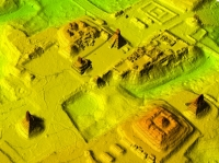
NCALM, jointly operated by UH and the University of California at Berkeley, is the only U.S. center of its kind that uses LiDAR (Light Detection and Ranging) technology – laser pulses – to create detailed earth renderings. Using these LiDAR-generated maps, NCALM researchers and archaeologists worked together to interpret the findings and uncover new discoveries, such as the ruins dubbed the "City of the Monkey God" in Honduras and the ruins of a megalopolis connected to the Mayan Snake Kings in Guatemala. Both of those discoveries generated worldwide media attention.
“Archaeologists were working on the ground in the summers, kilometer by kilometer,” said Shrestha. “If the work had continued in the classical archaeological method, they would not have finished in their lifetimes.” He expects more LiDAR-related contributions in the future.
Read the Houstonia article here.
